


Map images for emails, documents and listings.
A ready-made map picture of any place, with your markers and routes on it. It works wherever a normal image works: in booking emails, PDFs, print and search results.
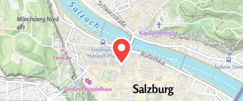
Markers, routes and areas on the map.
Mark one address or many places, draw a route or the outline of a region. Everything is drawn into the picture, in your colors.

Markers
One or many pins, with the standard marker or your own icon. The map frames them automatically.
Routes
A line along a route, in its own color and width, with arrows that show the direction.

Areas
Lines and areas from a file, such as the border of a country or the outline of a ski area.
Seven map styles to choose from.
Each picture below shows the same place. Only the style is different, from outdoor maps to a quiet light or dark background.
Summer
Winter
Hiking
Cycling
Street
Light
Dark
One web address per map.
Each map is one web address (URL) that describes the place, the size, the style and what to draw. Your system fills it in, and the API returns the image.
https://staticmap.maptoolkit.net/
  ?center=47.8005,13.0438
  &zoom=15
  &size=480x200
  &style=maptoolkit-maptoolkit.summer
  &marker=center:47.8005,13.0438
  &format=webp
  &api_key=YOUR_API_KEY
The request returns the map image with the marker, ready to be placed in an email.
PNG, JPEG or WebP
The image comes in the format you need. PNG is the default.
Up to 4096 x 4096 pixels
From a small thumbnail to a large header image.
Sharp on every screen
Two or four times the pixel density for high-resolution displays (ratio).
Fitted to an area
Give a region instead of a center and zoom, and the map frames it (bounds, bbox).
Long routes via POST
Very long routes or areas can be sent in the request body instead of the URL.
Cached for two hours
A map that was requested once comes from the cache for two hours by default (exptime).
Where map images are used.
Anywhere a live map would be too much, or would not work at all. Three common examples:


Search results and listings
Every result in a list gets its own small map, so people see at once where it is.
Tour sheets and PDFs
Printed itineraries and tour descriptions carry the route of each day.
Summaries in apps
A picture of the route in an activity summary, a notification or a shared post.
All maps on this page are images from the Static Maps API.
Questions about static maps.
Short answers on map credits, caching, several routes on one map and interactivity.
Does the map image include the map credit?
Yes. By default the API draws a small credit to Maptoolkit and OpenStreetMap into the corner of the image, so a map in an email or PDF carries its own credit. You can switch it off with attribution=false, for example when several maps appear in one document. Static images need a credit just like interactive maps, so then place one visible credit near the maps.
How do I get a fresh image instead of the cached one?
A map is cached for two hours by default, and during that time the same web address returns the same image. To set your own cache time, add exptime with a value in seconds, for example exptime=600 for ten minutes. Use exptime=-1 to skip the cache for a single request, which helps while you are testing changes.
Can I show several routes and markers on one map?
Yes. Repeat the marker parameter once for every pin, and the path or geojson parameter once for every line. Each one gets its own color and width. Colors are eight-digit hex values with the transparency at the end: FF0000FF is solid red, and FF000066 is a see-through red. Six-digit hex and color names do not work.
Can people zoom or move a static map?
No. The API returns a finished picture, so there is nothing to zoom, move or click. That is why it works in emails, PDFs and notifications, where scripts cannot run. If you want people to explore the map themselves, use the Vector Tiles API or the Raster Tiles API, which give you an interactive map on your website or in your app.
See your use case on a Maptoolkit map.
In the demo, one of our engineers walks you through the platform, your data and the move from your current provider.