


Your data on the map.
Connect the database, search index or file you already have. Maptoolkit turns it into a fast map layer with thousands of points, and your search and filters keep working as before.
Works with your stack.
Connect a database or a search index, any web address that returns GeoJSON, a file (GeoJSON, GPX, KML, CSV, Excel, Shapefile and more), a PMTiles archive or an existing tile server. If none of these fits, a few lines of JavaScript can read any other source.








 + many more
Search and filters keep working
The same queries and filters you use today select what appears on the map.
Set up in about five minutes
A step-by-step setup in the browser, without changing your system.
Always up to date
The data is read again on a schedule, or right away when it changes.
Your data stays where it is.
The connector reads your data source, keeps a copy and turns it into map tiles. Your system stays as it is, and repeated requests do not reach it. Connectors are part of Maptoolkit Enterprise.
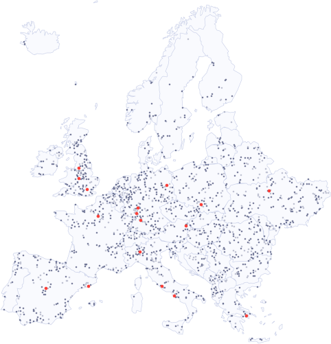
Thousands of points, easy to explore.
A connector layer stays fast with tens of thousands of items, and visitors find what they need:
Grouped when zoomed out
Nearby points are combined into one circle with a count, and split up again as visitors zoom in.
Filters on the map
The filters of your search decide what the map shows, for example only huts at 2,000 m or higher.
Search by name
Visitors type a name and the matching place appears on the map, with your own data.
One address for your map.
Each connector has its own web address with map tiles and a TileJSON, so you add it to MapLibre or Leaflet like any other layer.
// A connector named "huts" as a source in MapLibre
map.addSource("huts", {
  type: "vector",
  url: "https://dataconnector.maptoolkit.net/ACCOUNT/huts.json?api_key=YOUR_API_KEY",
});
// Search the same data, the answer is GeoJSON
const res = await fetch(
  "https://dataconnector.maptoolkit.net/ACCOUNT/huts/search?query=Glorer&api_key=YOUR_API_KEY"
);
Vector or image tiles
Vector tiles up to zoom 18, image tiles up to zoom 20, and a TileJSON for map libraries.
Search and filters
Search returns GeoJSON, up to 1,000 results per request. Filters are JSON expressions (filter, query).
Points, lines and areas
Every kind of geodata. Export a feature as GeoJSON, and a line also as GPX or KML.
Several sources in one layer
Group connectors with a tag, or join their names in one address (pois-hotels).
Updates
Reload every few hours (reload_interval), or trigger an update through the REST API.
API key and permissions
Every request carries your key (api_key); permissions decide who can read a connector.
Where connectors are used.
Wherever many places already live in a database or a search system. Three common examples:
Tourism portals
Every hotel, guest house and apartment of a region from the booking system, on one map.
Mobile apps
Thousands of locations from your own database, smooth to zoom and pan in the app.
City and open data
Fountains, toilets or parking from a city database, kept up to date on the city map.
Points in these examples are OpenStreetMap data (October 2026).
Questions about Maptoolkit Connectors.
Short answers on data sources, updates, uploads, large datasets and personal data.
Which databases and services can a Maptoolkit Connector read from?
PostgreSQL, Supabase, Google BigQuery, Airtable, Elasticsearch, Apache Solr and imx.Platform, as well as any web address that returns GeoJSON, an uploaded file, a PMTiles archive or an existing vector tile server. If your source is not on the list, a few lines of JavaScript can fetch the data and hand it to the connector.
Does the map query my database every time someone looks at it?
No. The connector reads your data when it loads or reloads it, keeps a copy and serves the map from that copy, so visitors never reach your database. It only reads from the address you set up and never writes to it. For some sources, such as Elasticsearch, search requests can be passed on to keep results live.
How do I put a spreadsheet on the map?
Upload it in the connector setup in your browser. Besides CSV and Excel, the upload takes GeoJSON, GeoPackage, GPX, KML and zipped Shapefiles. You then point the connector to the columns that hold the location, either latitude and longitude or a geometry. You can keep several versions of a file and switch the active one.
How many points can a connector layer handle?
Our own demo shows 920,979 places to stay worldwide from a single uploaded file. When zoomed out, the server groups nearby points and sends one circle with a count per group, so the map stays fast. From zoom level 14, every place appears on its own. Filters, such as type or stars, are applied on the server before the map is drawn.
Can I connect data that contains personal information?
Personal data should not reach Maptoolkit through a connector. If your table also holds personal fields, such as names or email addresses, connect only the columns the map needs, for example with an SQL query or a Supabase selection that leaves the personal columns out. Locations of shops, hotels or trails are fine.
See your use case on a Maptoolkit map.
In the demo, one of our engineers walks you through the platform, your data and the move from your current provider.